Ever noticed how many fantasy maps will detail the ocean on the left, western side? In many cases there won't even be an eastern or northern shore; however, there may be a southern shore.
The main reason for this is the popularity of Medieval European Fantasy. A Fantasy Counterpart Culture of Medieval Europe will naturally imitate the geography of Europe: ocean to the west and vast stretches of land to the east. For the same reason, the north is often a harsh tundra full of barbarian tribes, the east a mysterious land whence ride the Hordes from the East, and the south a hot land of jungles, tropical islands, and savages.
An interesting historical aside: Throughout most of the middle ages, maps were drawn with East at the top, rather than North. (This is how the word "orient" came to mean "face the correct direction.") A fantasy map that followed this convention would be bottom-justified, instead of left-justified.
When an Expansion Pack World is applied, this trope often leads to an Eastward Endeavor, or sometimes to a Quest to the West if the characters are interested in crossing the sea.
See also: Patchwork Map; Standard Fantasy Setting.
Examples:
- Invoked in Altina the Sword Princess, which is essentially a fictional analog of 18th-19th Century Europe.
- In The Familiar of Zero, the political geography is a blatant magical analog of Medieval Europe, so this is naturally the case.
- Inverted in Naruto, where the ocean is on the east side of the map, likely because its world is based generally on feudal Japan (where the ocean is mostly to the east).
- Also inverted in Nausicaä of the Valley of the Wind, with the Ocean of Salt and the Inland Sea to the east of the lands where the story takes place.
- Entirely ignored in Fullmetal Alchemist, despite being set in what is obviously a European analog. Amestris is landlocked and surrounded by lots of much larger countries. There is mention of an island nation beyond Xing, however, and the larger map of the world briefly glimpsed in episode 64 of Brotherhood showcases a small amount of ocean touching upon Aerugo, the nation to the south and east of Amestris, thus making the Fullmetal World a bit more of a right-justified map (an even briefer glimpse of a chalk drawing of the world is glimpsed in the flashback to King Bradley's childhood, showing continents similar to Earth's with Europe, Africa and Asia kind of merging a bit around the Middle East, which is likely where Amestris and its fellow nations are located)
- Artesia inverts this, the eastern part of the map where all the action happens is almost a mirror image of Western Europe, with a sea surrounded by land on three sides and opening into an ocean to the east.
- The Lands of Arran, a world inspiring itself like most fantasy stories from Europe, and the map
 ◊ is dominated by the eastern sea with various archipelagoes scattered in the middle of it, with a supercontinent to the East and what appears to be a smaller one to the South.
- Inverted twice in With Strings Attached; Focan is on the east coast of Ketafa, and Ta'akan is on the Shining (east) Coast of Baravada. (The west coast of Baravada is known as the Rust Coast.)
- Star Wars: Though a sci-fi franchise spread across a galaxy, maps of that galaxy consistently portray the known regions as being to the east with the Unknown Regions to the west.
- Titan, the (main) Fighting Fantasy world, has the majority of adventures take place on the West Coast of Allansia, particularly "Port Blacksand". Averted for those gamebooks taking place on the other two continents, the Old World (which mostly feature the kingdoms near the northern and eastern coast) and Khûl (which usually take place near the southern coast).
- The land of Kabaran in The Return of Zaltec. Slightly averted in the sequel, Zaltec II: The Generation Stone where you visit another land to the west, but that land doesn't appear in most of the in-game maps.
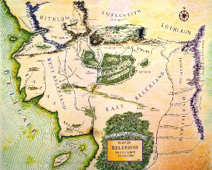
- The Lord of the Rings could have started this phenomenon. J. R. R. Tolkien had set out to create a mythology for Europe and especially England (the available myths, such as Camelot (which is really French/Welsh) and Beowulf (which is Anglo-Saxon and set in Scandinavia), being alien to the modern English culture) and thus, in the context of the fantasy, Middle-earth is supposed to be western Europe as it was in the extremely distant past.
- That conception became less clear as time went on so that some believe that by his death Tolkien no longer intended Middle Earth to be in any way related to the real world. Besides that, he had maps that showed the rest of Middle Earth; it's just that the events of both The Silmarillion and The Lord of the Rings take place in the west, at least partly because it was closer to the Blessed Realm and Númenor and because that was where the Kingdoms of the Noldor and of Thingol were.
- Note that what we're looking at in The Lord of the Rings is the drastically reduced version of it—the cataclysm that ended the First Age (at the end of the main text of The Silmarillion) drowned Beleriand, a region nearly as vast as what is shown in the Rings map. The Blue Mountains, the east border of Beleriand, became the westernmost mountains of later Middle-Earth.
- This may also have been what happened with the mountains, which are so unrealistic as to make geologists discuss them in terms of car-wreck fascination.
- Two things worth remembering; Tolkien was writing at a time when Plate Tectonics was very poorly understood, and thus it was conceivable that the landmasses depicted in his maps could be formed into the modern-day continents within the span of a few thousand years. And secondly, the world of Middle Earth is very explicitly the result of intelligent design, and therefore not necessarily subject to the same rules that govern real-world mountain formation.
- Bottom justification happens on Dwarven maps such as the one in The Hobbit, dwarves preferring the east as the chief direction as mentioned above.
- Eragon: The part of Alagaësia where all of the action takes place has giant woods flanking it from north and north-east, mountains in the south and east, and sea in the west and south-west.
- Redwall. Mostly true, although occasionally when we see a full map of the Northlands, such as in Martin the Warrior, we do see a northern and eastern coast as well. It's just that the bulk of the action takes place in Mossflower, which is on the western coast of the landmass and further south - it's roughly triangular, like Great Britain, on which it's based.
- The Sword Of Shannara. Justified: It's actually the Pacific Northwest After the End.
- Bored of the Rings (But mainly because it was aping and satirizing the style of The Lord of the Rings. The map actually has less relation to the story than to the Rule of Funny.)
- Inverted in C. S. Lewis' Narnia, which is right-justified with the sea on the east; an interesting departure from the Avalon-in-the-West orientation pervading Tolkien and his imitators, and all the more remarkable because CS Lewis was friends with Tolkien. One explanation for this is that the sea is in the west in The Lord of the Rings because the world is fading like the setting sun. The sea is in the east in Narnia because things are always getting brighter and better. Due to Lewis's aforementioned relationship with Tolkien, this led some to theorize that Narnia was in fact the other half of the continent Middle-earth was a part of, though they clarified this wasn't the case.
- Used in the book Gifts by Ursula K. Le Guin. Gifts and its sequels Voices and Powers are now collectively known as the "Annals of the Western Shore", which may or may not be lampshading.
- The Tortall Universe by Tamora Pierce, considered from the point-of-view of Tortall itself, as well as the other "eastern lands". It has a southern coastline (and the continent to its south naturally has a northern one). The western ocean would be analogous to the Atlantic if it didn't have Yaman in it.
- Averted with Pierce's other series, Circle of Magic. It's left-justified only in the small map of Winding Circle and its immediate surroundings. The map that shows the entirety of Emelan and its neighbors is bottom-justified with the Pebbled Sea to the south. Namorn's map in Will of the Empress is top-justified with a coastline formed by a lake large enough to be considered a freshwater sea.
- In Jennifer Fallon's Wolfblade Trilogy, the kingdom (or princedom or whatever) of Hytria is in the center of the continent, with the Dregian Ocean to the south, Fardonyha on the west, who shares part of the ocean, and Medalon to the North; the west part of the continent is "uncharted".
- Both The Belgariad and The Elenium provide world maps like this. Interestingly, their respective sequels both take place on the then-charted lands of the far east, complete with maps. It should be noted that Eddings takes world-building very seriously.
- The Riddle Master Trilogy has a right-justified map with uninhabited Badlands to the West. (The realms of the High One were colonized by humans two thousand years ago from across the ocean, but their original homeland is never mentioned, nor has anyone ever found anything of note beyond the Badlands.)
- Subverted in the Earthsea series, where the ocean lies to the west, east, north, and south. In fact, the whole planet is ocean, aside from a dense scattering of islands.
- The Sea of Knowledge in The Phantom Tollbooth is located to the east; to the west are the Lands Beyond (i.e., our world). This is no doubt linking the Enlightenment of knowledge with the rising sun.
- Since Dies the Fire and its sequels mostly take place on pacific coast, it also follows this trope. However, The Scourge of God takes place in the Midwest, and thus has no coasts (Unless counting the Great Lakes), and then the Sword of the Lady roams from the Mississippi to the East Coast, thus avoiding the trope. Also, since it takes place on an Alternate History Earth, there do exist several maps that detail the rest of the world, at least in-universe.
- Maps of Mid World from Stephen King's The Dark Tower series place a lot of emphasis on the West. Though the eponymous Tower is set in the southeast, known as End World, major locations such as the Western Sea, Gilead, Tull, the Way Station, Hambry, Mejis, the Cyclopean Mountains, and Shardic's Lair are all in the western half.
- The Clean Sea is a body of water to the south, making the land vaguely horseshoe-shaped.
- While Terry Pratchett's Discworld is fully-designed, it started out as a left-justified fantasy map because the Hub is analogous to the North and Ankh-Morpork and the Circle Sea are on the Turnwise (I.E., west-analogous) side of The Continent. Despite having created a China-esque continent surrounded by a South Pacific ocean (which is, oddly enough, the first major land-mass turnwise from A.M.) and a continent which in no way is intended to resemble Australia, though it may be a bit Australia-like here and there, it remains a Left-Justified Fantasy Map because the Widdershins end of The Continent has never been shown past Überwald. In the first released version of the Discworld Mappe (in 1995) practically everything on the far side of Überwald was an undescribed and undifferentiated "Here Be Dragons" void space, all the way out to Genua. The use of this trope is likely intentional.
- The Compleat Discworld Atlas, released twenty years later in 2015, contains a far more detailed and defined Mappe that fills in many of the blanks present on the 1995 version; the accompanying gazeteer also contains illustrations as well as text descriptions that describe many Discworld countries for the very first time, including its "Russia" and its "USA"-analogue.
- Although the only part of the ocean anyone talks about is to the west, the land in Broken Sky actually averts this, being surrounded on three sides by the ocean. This actually becomes a plot point during the Final Battle: when King Macaan activates a device that summons (and enrages) the very, very large sea monsters inhabiting the western ocean, the device is on the eastern shore, so the monsters will have to trek through (and destroy) the rest of the country on the way. One of the biggest, and craftiest, beasties is smart enough to swim around the country and approach from the opposite direction, showing up right at the high point of the fight.
- Justified by Hyborian-age Earth in the original Conan stories, as Robert E. Howard's mythos was set in a time after Atlantis sank but before known ancient civilizations had arisen, using Europe, Asia, and Africa as a model - at a time when plate tectonics were virtually unknown, and so still plausible at the time.
- Andrzej Sapkowski never delivered an official map of the Witcherland. However, all the snippets of geography that do get provided in the books follow this trope to the T. Thus, the various maps that have been created by others are left-justified.
- The Arcia Chronicles is guilty of this trope. The author has averted it, however, in her other series, Reflections of Eterna, which provides a map of the entire continent (and the country central to the plot spans most of it).
- Andre Norton's early Witch World novels had a map that just showed Estcarp and its hostile neighbors to the north and south, with ocean to the west and mountains to the east. Justified in that the inhabitants of the western lands were all under a spell. The folks living to the east of the mountains didn't want the western lands' problems spilling over to their territory, so every time they westerners wondered what was east of the mountains they immediately forgot that they had. The spell was finally broken by the Tregarth triplets, who ventured east and had adventures there. Later maps showed continents on both sides of the western sea, and another sea far to the east.
- In the Warrior Cats series, the Great Journey map has the sea to the southwest.
- Zigzagged in A Song of Ice and Fire, whose world map reflects the limitations of medieval maps.
- Westeros is the westernmost landmass in the world. It is the fantasy equivalent of the British Isles, though continent-sized and contains equivalents to other parts of Europe. The western sea is called the Sunset Sea, and there is no known land in that direction. Lord Gylbert Farwynd of the Lonely Light, the Westernmost of the Iron Islands and point of land, claims there is a paradise-like land to the West. Many of the Iron Islanders don't believe him and think him mad. Westeros sits off the western shore of Essos, which is the fantasy equivalent of Eurasia.
- On the other hand, Essos extends beyond the eastern limits of all official maps, so its eastern shores are never seen. The continent is surrounded by two oceans: the Shivering Sea in the north and the Jade Sea in the south, beyond each is uncharted territory. To the south of Essos, west and east of the Jade Sea, respectively, are two continents: Sothoryos, the equivalent of Africa, and Ulthos. Most of Sothoryos is unmapped, while Ulthos is completely unknown, with no major character hailing from there (Missandei was born in Naath, an island off the coast of Sothoryos, although she was raised in Essos).
- To summarize, there is sea in the west... and south and northeast.
- The Kingkiller Chronicle uses a very Europe-like map, with sea to the north, west, and south and land to the east and southeast.
- In The Dagger and the Coin series, it's played as straight as could be. The map looks more like Europe than a casual cartographer could draw.
- Subverted by Robin Hobb's Realm of the Elderlings, with the ocean on the right side of the map. The peninsula of the Six Duchies, which the first and third trilogies centre around, is real-world Alaska flipped upside-down and placed on the right-hand coast.
- The Monarchies of God series by Paul Kearney plays this very straight. The landmass looks similar to Europe and there is a huge, undiscovered continent to the west of the ocean.
- Heralds of Valdemar: Valdemar and its neighboring countries are landlocked, but are on the western side of the continent. The sea is beyond the Pelagiris Forest, which is full of monsters and Wild Magic. Off east is the mysterious Eastern Empire.
- Annals of the Western Shore rather has to have one, otherwise it would be Annals of the Eastern Shore.
- Tad Williams' series Memory, Sorrow, and Thorn gives us vast unexplored ocean to the west◊ of main land-mass where all the events happen.
- Averted in the Crescent Moon Kingdoms novels by Saladin Ahmed; ocean surround the lands in question on the west, south, and east.
- Barbara Hambly's series The Windrose Chronicles showcases this as well, though in the story the parallel seems to be drawn to California rather than Western Europe.
- The Wheel of Time by Robert Jordan: Grim Up North? Check. Hordes from the East? Check. Ocean on the left? Check. Hot jungles in the south? Che-oh wait, no jungles. There is, however, a swampy southern shore. The series plays with the convention in two ways, though: the protagonists spend a fair amount of time off the eastern edge of the map, in what turns out to be a harsh desert. Maps of this area are never shown, and there's another country even further east that is never explored. Secondly, although there are several factions that could qualify as Hordes from the East, the ones who do the most damage throughout the series actually come from the west, over the sea. Nobody sees this coming.
- Inverted in the Nightrunner series. Interestingly, it does somewhat resemble Europe, but from a Greco-Roman perspective. The civilized nations are mostly concentrated on landmasses extending from the south of the continent with the Gathwayd Ocean stretching beyond and other (unnamed) nations on its far shores. Heading north, east or west, takes one into unsettled, barbarian or just flat-out mysterious territories.
- The Witchlands, the eponymous continent is connected to the Sleeping Lands in the North and the Eastlands (guess where) by land and flanked by water in the South and West, as seen here.
- R.A. Salvatore's Demon Wars series inverts this, as the setting's map is very clearly based on the northeastern corner of North America (the outlines of Canada's provinces of Quebec and the Maritimes are especially recognizable).
- The rare fantasy trope that doesn't appear in The Tough Guide to Fantasyland, which has a right-justified map. This is because it's even more blatantly Western Europe than usual, but flipped upside down.
- World of the Five Gods also has a right-justified map, because it's a map of Europe rotated 180 degrees.
- Gor: The setting has the Thassa (ocean) to the west and the Barren Lands (steppe) to the east. It is unknown if there is anything beyond the two.
- The Old World in Warhammer is a not-very-subtle version of Europe (and beyond), so the layout is much the same as a real-world map. As the primary focus is on the Empire (Germany), Bretonnia (France), and the frozen, inhospitable wastelands only inhabited by desperate, drunk, and brutal deformed humans (Scandinavia), that's what most of the maps show. The larger map is has approximations of North & South America, East Asia including an island named "Nippon", Africa. England is represented as the island "Albion" (which despite the origins of the game, wasn't particularly explored until 2 decades into its lifespan). The biggest changes are that there is a gigantic circular island planted in the middle of the Atlantic Ocean equivalent and that Australia & South East Asia is smushed into a handful of large islands or pushed into the Antarctic equivalent "Southern Wastes".
- Warhammer 40,000 takes this concept (like so many other concepts from plain ol' fantasy Warhammer) and launches it into space. No noticeable geographic features, obviously, and exceptions apply, but the galaxy of 40k is divided into Segmentum including, for example, Obscurus (up "north", featuring Fenris, planet of the space Vikings and Vostroya, the planet of space Russians) and Ultima (out "east", featuring the Animesque Tau and space Mongol White Scars).
- Somewhat inverted in 40k as well, since Holy Terra, the center of the Imperium and the beacon all navigation is based on, is in the "western" part of the galaxy (a departure from real life, where Sol is usually depicted in the "south"), and the Astronomican that makes warp travel possible doesn't reach all the way to the eastern edge, thus leaving the entire western edge of the map explored (as explored as space can be, at least), while the far eastern edge remains relatively unknown.
- Exalted's map works like this. In fact, there's literally nothing beyond the western border these days except the "Elemental Pole of Water" and primordial chaos.
- Inverted in Legend of the Five Rings: the ocean is due East, which shouldn't be surprising as Rokugan is a Fantasy Counterpart Culture of Japan and China.
- The Dungeons & Dragons setting Forgotten Realms core setting. Avoided in almost all other settings: In Greyhawk, Mystara, and the Kara-tur and Maztica FR supplements, the ocean is on the right (which is only natural in the case of the latter two: Kara-Tur is on the far eastern edge of the Realms' supercontinent while Maztica is another continent across the ocean to the west); while in Red Steel (a spinoff of Mystara), the ocean is on the south; and in Dragonlance, Eberron, and Al-Qadim, the map shows both coasts (Technically speaking all four in Eberron's case, since Khorvaire is an island continent ala Australia). Ravenloft in its original release features an ocean on its western side, though in a later edition the Mists that surround it expand out to reveal an ocean on the eastern shore. Somewhat justified in that Ravenloft is an artificial demiplane whose geography is subject to change, alteration, or erasure by the Dark Powers at the drop of a hat. Planescape's primary setting has no maps.
- Faerûn's east coast at the Great Ice Sea does appear on some maps as well, although it generally fulfills the trope. Later maps do show the entire planet, however, so it's more a case that the Faerûnian continent 'traditional map' fulfills the trope, but the actual world and setting does not.
- Zig-zagged in Birthright. The basic rulebook and accompanying materials focused on the fractured nation of Anuire, which is positioned on the southwest edge of the setting's main continent of Cerilla. Accordingly, it was ocean to the west and south (though with a destroyed land-bridge to the "Old World" continent of Aduria), and land to the north and east. However, as more sourcebooks for the setting were released, the continent's map was eventually fully expanded and all of Cerilla was detailed, ultimately subverting the trope.
- Pathfinder's default Inner Sea setting is also like this, being that it's also a fantasy Europe and Northern Africa equivalent. Like the Forgotten Realms, maps of the whole world have been made, and they of course avert the trope (although there are some interesting divergences from both Toril and Earth).
- Inverted in the Dragon Empire default setting for 13th Age, where the "monster-spawning edge of the world", the Iron Sea, is located in the east. It's unclear whether there's anything on the other side; it's a bit hard to get ships across, because of all the monsters.
- In The Dark Eye, while Aventuria is bordered by ocean on all sides except the northeast, the more prominent (and earlier fleshed out) settings are located on the western part of the continent. Justified in-universe, as the settlers of the now dominant nations first landed there.
- Generally avoided in Might and Magic — the only game in the RPG series to do it was VII, and then in a highly downplayed fashion (the main area is surrounded by ocean on all sides, but there is a comparatively small island to the south-east that extends beyond the eastern edge of the map). All other games either had other combinations (ocean on all sides but the west, ocean on all sides but the north, ocean only in the south, ocean all around without exception) or showed the entire world (or in IV-V's case, one respective side each of the flat world).
- Fable, Fable II. Based on the name of the region ("Albion"), it would seem to be a fantasy version of Britain. Based on the map from the original game, it's Wales and Cornwall plus a split-in-half Ireland, all shortly after the Ice Age.
- Fable III has its map with the east at the top, and shows a little of a new continent beyond the western ocean of Albion.
- Fe, set in Scandinavia, plays this trope straight with the ocean being on the west side of the map.
- The Legend of Zelda: Majora's Mask has the ocean located on the western side of the map. No relation to Japan, which is an island.
- Inverted with the original The Legend of Zelda, where the ocean is to the east and south. Same goes for Zelda II: The Adventure of Link, set north of the original with Death Mountain as a divider, even features another Hylian continent beyond the ocean.
- Oddly averted in The Legend of Zelda: A Link to the Past, The Legend of Zelda: Ocarina of Time, and The Legend of Zelda: Twilight Princess, where there is no coast or ocean. The largest body of water is Lake Hylia, which is landlocked (and to the south).
- The Legend of Zelda: Skyward Sword, however, reveals that the westernmost desert used to be an ocean.
- And in The Legend of Zelda: Link's Awakening, The Legend of Zelda: The Wind Waker, and The Legend of Zelda: Phantom Hourglass, where the ocean is everywhere (and in the case of Link's Awakening, at least, the only actual shoreline you can access is in the south).
- Both The Legend of Zelda: Oracle Games have the ocean to the south.
- In The Legend of Zelda: Spirit Tracks, the ocean is in the southeast.
- In The Legend of Zelda: Breath of the Wild, the ocean is to the south and east, as in the original game.
- Final Fantasy Tactics, where Ivalice is surrounded by ocean at the East, West, and North, due to the eastern is up map, but the continent (and the neighboring nation of Ordallia) continues southward indefinitely.
- Averted in the other Ivalice games. In Final Fantasy XII, Ivalice (this time a region in the same world) resembles a horizontally-flipped Mediterranean, while in Final Fantasy Tactics A2, Jylland is formed from two peninsulas jutting towards each other (despite the presence of Goug city suggesting it's the same area as the original Tactics' kingdom, just in a different time).
- Zig-zagged depending on the content in Final Fantasy XIV. Most of the game plays it straight, with the continent of Aldenard made up of a larger landmass to the east (made up of the forests of the Black Shroud, the deserts of Thanalan, the frozen wastes of Coerthas, the grasslands of Dravania, and the rough mountains of Gyr Abania) and a smaller island in the west, Vylbrand (solely the temperate La Noscea), and with a connection to another continent, Ilsabard (not playable as of yet, but the domain of Garlemald and the conquered territories it's held onto the longest) in the northeast. Stormblood, however, inverts this with the introduction of Othard, which as a Fantasy Counterpart Culture of east Asia has the smaller island (Hingashi) to the east, separated by a smaller Ruby Sea leading to the greater landmass (the hills of Yanxia and the Azim Steppe) further to the west.
- Fire Emblem series for the most part has its continents fully surrounded by ocean, but also a number of those which play it straight.
- The continent of Elibe (setting of Binding Blade and Blazing Blade) is surrounded by water from all sides, with the exception of a stripe of land that lies east of Sacae (itself a Fantasy Counterpart Culture of Mongolia), and gets cut off by the edge of the map.
- Tellius (Path of Radiance and Radiant Dawn) seems to be a large peninsula, with a large desert east and north of Daein and Begnion. Unusually for the series, there's at least one nation located outside the map's borders - Hatari, that lies beyond said desert.
- Fódlan (Three Houses) is a region that borders with countries of Sreng and Almyra, which go beyond northern and eastern borders of the map, respectively. There are some islands to the south and west of Fódlan, with Albinea being the largest, but they are never visited in the story. This is another case of Europe-inspired fantasy world, with Sreng and Almyra being at least partially based on Northern Europe and Persia/Iran, respectively.
- Inverted in Dragon Age: see the world map here◊ (quite literally inverted: if you rotate and/or flip it, you'll arrive to a map that looks suspiciously like Middle Ages Europe). Also notable for everything being set in the southern hemisphere, rather than the traditional northern one. Not that it has much impact on the generic Medieval European Fantasy setting, but still.
- Mostly averted and oftentimes inverted in the Pokémon regions. Kanto and Unova have oceans to the south and east; Johto and Fiore mostly have southern coastlines; Hoenn is a large island with numerous smaller islands to the east; Sinnoh is a roughly diamond-shaped island or peninsula with oceans on all four corners of the map and east as the only cardinal direction with a coastline; Almia is mostly a south-pointing peninsula; Alola is a chain of Hawaii-inspired islands; Galar is based on Great Britain and has ocean to the east and west; and Paldea is based on Spain and Portugal and thus is surrounded by ocean, with the only land extending past the map located in the northeast. The only regions to play it straight are Kalos, which, fitting the trope description, is based on a European country (France), and Orre, which oddly enough is based on Arizona.
- The map of Wesnoth and neighbouring areas on the Battle for Wesnoth splash screen puts the Great Ocean on the left side. The map is also used for most storytelling segments of the campaigns.
- Played straight in Myth: The Fallen Lords whose map also looks very similar to that of The Silmarillion.
- Guild Wars: All three continents, even though one of them is an island and really should have eastern and southern borders. However, Tyria's landmass features a gigantic western peninsula (its isthmus contains an entire country) whose furthest edge is cut off the map, suggesting that there may be more land to the west.
- Inverted in Drakengard where the open ocean is on the north and east - however, this is because the map is literally an upside-down map of Europe.
- Inverted in Perfect World, which is rather reasonable since the game was created by Chinese.
- Played straight in Star Control II, with Earth being located near the bottom left corner of the map (although both the Pkunk and the Ilwrath's territory was farther into that corner than Earth was). Star Control III, assuming it ever happened, took place in an unexplored part of the galaxy off to the bottom right of the map.
- Mass Effect: Using the Citadel as the cultural center of the galaxy, this is Played Straight in the Galaxy map in all three games, with the Citadel being in a star system near the far left of the map. Interestingly, Earth's territory is farther to the right on the bottom of the map, with batarian space being in the bottom right. When the Reapers invaded in the third game, they started in the bottom right and worked their way up and towards the left, taking out the batarians and Earth first.
- Jagged Alliance 2 used a square map with shores on the west and south. Direction of emphasis was from top-right (the location of the only airport you have access to for the majority of the game) to bottom-left (the location of the enemy-controlled capital). The original Jagged Alliance game was set on an island, but also featured advancing from right to left (this time, from your base in the bottom-right to the enemy base in the top-left).
- Averted in The Last Remnant, with the game's world being a Pangaea-style supercontinent.
- Averted in Achaea, which initially appeared to be a single contiguous continent surrounded on all sides by water. A continent directly south has since been discovered.
- Seemingly played straight in Pillars of Eternity, though it is actually a slight twist on the trope. Eir Glanfath is basically Eora's North America equivalent, being a "New World" discovered and colonized by older cultures, who came from across the sea to the west and south.
- Pillars of Eternity is also set in the southern hemisphere, with the very Inuit Boreal Dwarves coming from the Grim Down South.
- Fallout series:
- Fallout and Fallout 2, being set in a future southern California and future northern California and southern Oregon, respectively, have maps justified like this.
- Fallout 3 avoids the issue entirely by not being set in an area where an ocean is easily reachable, and the only noteworthy body of water is a river that cuts through the center of the map from northwest to southeast.
- Fallout: New Vegas inverts this in a manner of speaking, as the "ocean" in question is actually just another river cutting off the southeastern-most portion of the game's world. While you can cross it, the only noteworthy location on the eastern bank is Fortification Hill.
- Inverted in Fallout 4, as the game is set in Boston on the East Coast, so the ocean is on the right side of the map.
- The Legend of Dragoon has the continent of Endiness. Along its eastern border is an unidentified landmass, so it appears to be a peninsula of sorts similar to Europe.
- In the first Warcraft game, Warcraft: Orcs and Humans, the world of Azeroth was pictured◊ with a "Great Sea" in the south-western side and swamps and rock formations on the eastern side. Later games avert this however by adding more regions to the world, making the Orcs and Humans world the eastern continent.
- While Blood Omen: Legacy of Kain showed the realm of Nosgoth to be land-locked - it was in fact very unclear whether Nosgoth was meant to be the name of the country or the whole world, and further it was unclear as to whether or not the world was meant to be a globe at all - the fourth game in the series revealed that Nosgoth did in fact have a south-western coastline that had been just slightly further than previous maps had shown.
- Lunar: The Silver Star has you start on an island in the Northwest corner of the map, generally progressing East across the continent.
- Spirits of Anglerwood Forest: There's a sea to the southwest of Anglerwood Forest. The level select screen is a map and only shows a portion of a continent. It's even labeled "Southwest Anglerwood Forest".
- Puzzle Quest: Challenge of the Warlords: The world map of Etheria has the sea mostly from the west, though it's located south of the endgame areas.
- The Dragon Doctors takes place in an area based off of Northern California, with deserts to the south, rain forests to the north, mountains to the east, and ocean to the west. In fact, it is California, but far into the future and after the landscape has changed due to a magical disaster.